MULTIBEAM BATHYMETRY
MESURIS, the first commercial company to produce the fusion of multiple data sources in an interactive representation to facilitate the interpretation of mapping.

Originaly, the bathymetry consisted of contour lines printed on paper which were obtained by a single vertical sonar beam under the survey boat. Between two contour lines, the software extrapolated data.
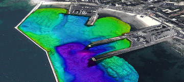
The multibeam survey provides a full underwater coverage extende to structures above the water with TOPOMETRYXTM HR. It is easier to appreciate the topography of the sea floor by introducing colors which represent the depth of the terrain model;
BATHYRELIEFTM refers to the fusion of different data sources : bathymetry, laser scanner data, construction plan, airborne digital image… in order to prodeuce an interactive representation of the terrain on PC or Mac
The 3D interactive digital terrain model is viewed from any angle. BATHYRELIEFTM also allows to compare and visualize erosions or sedimentations. Depending on where the cursor is placed, the operator has the possibility to zoom over seas of interest and instantly read elevation level.
BATHYRELIEFTM has very quickly been appreciated by users, particulary by contractors. In fact they have found a way to present their resulys on an interactive way, immediate readings of the sea bed elevation on any point.
BATHYRELIEFTM can collect information from both Survex and GEOSUB 3DTM QINSy real time acquisitions systems. Files are produced with Fledermaus software from QPS and provided on USB dongle with free reader Iview4D.
SERVICES
- VISUAL AID FOR ACCURATE UNDERWATER PLACEMEMENT OF ARMOUR UNIT
- MULTIBEAM BATHYMETRIC SURVEY
- SURVEY INSPECTION
- DATA PROCESSING AND VOLUME COMPUTATION
- SIDE SCAN SONAR SURVEY AND SUB BOTTOM PROFILING
- 3D INTERACTIVE VISUALIZATION
- ELECTRONIC SYSTEM INTEGRATION FOR MARINE APPLICATION
- RESELLER FOR : TELEDYNE TSS, RESON, QPS, MSI and GENERAL ACOUSTICS
HEAD OFFICE AND WORKSHOP
SERVICES
37 rue de l’Océan – 56470 SAINT-PHILIBERT – FRANCE
MARKETING CONTACT :
+33(0)2 97 30 01 55
TECHNICAL CONTACT :
+33(0)2 97 30 08 95
DATA MANAGEMENT AND PROCESSING
Rue de la Terre Victoria – EDONIA B
35760 SAINT-GREGOIRE – FRANCE
+33(0)2 99 23 42 01


